by Karyn Klaire Koski
Left undisturbed for thousands of years, an ancient buried river exists about 50 meters below High Park. It lies within a glacially modified trench that starts 110 km away. Sections of this underground trench are known to be up to 30 km wide.
The buried river’s water is cold, iron rich and very slow moving. The valley is buried beneath a thick sequence of gravel, sand, silt and clay sediments. It also contains pockets of coarser sand and gravel that yield large amounts of groundwater. These pockets are called aquifers.
Proof of the Laurentian River’s existence as far south as High Park occurred in 2003 when work crews drained Howard and Ridout Ponds in the Park’s northeast section (to enlarge these sedimentation ponds). They discovered previously dug and capped wells from the late 1950s. A deep borehole observation well was dug nearby to explore the bedrock levels and test the waters below. It unexpectedly erupted geyser style indicating that a source of unreleased pressure had been struck.
How it was discovered in High Park
In the late 1800s, geologists discovered clues that suggested a preglacial drainage network existed that centred on the Great Lakes Basins. This extensive drainage network was a valley system created by the erosive forces of rivers which had cut deep, deep gorges; the result of millions of years worth of scraping and melting from vast ice sheets. The Laurentian River is only one channel within a larger drainage network.
The Laurentian River or Channel stretches from the Wasaga Beach area (on Georgian Bay) to High Park, Toronto (on Lake Ontario). It lies within a 110 km long bedrock trough, that in places, measures roughly 30 km wide. It is also believed to continue north from Wasaga Beach beneath Georgian Bay and also more southeastward beneath Lake Ontario. Its true length is still unknown.
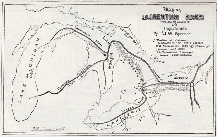
Water flowed along the Laurentian Channel prior to glaciation and also perhaps during some episodes of de-glaciation, (as the ice melted). Then the Laurentian Channel was left buried and infilled with up to 200 m of sediments consisting of a mix of gravel, sand, silt, clay and glacial till. Because it is so deep, it is difficult to observe and research.
The base of the valley lies at an elevation of about 25 m above sea level in the northern part of Toronto (in a borehole drilled near Weston Road and Finch Avenue) and at about 96 m above sea level further north (in a borehole drilled to the west of Barrie). Based on these key locations, the bottom of the valley at Wasaga Beach on Georgian Bay is believed to be about 63 m below the Georgian Bay water level. At Lake Ontario the bottom of the channel is believed to be at an elevation of about 30 m below the Lake Ontario lake level. This drop indicates its southerly flow.
Within the channel are many pockets of subsurface gravel and sand. These are called aquifers, which can also contain vast amounts of slow moving groundwater. One such aquifer was discovered in High Park during the summer of 2003.
After draining Howard & Ridout Ponds, work crews located two capped wells that had been dug in the late 1950s. A discovery borehole was drilled nearby. Expert hydrologists encountered bedrock at a depth of 44.5 m (146 ft), which was at an elevation of about 42 m above sea level. Since the bottom of the valley is believed to be lower, the Spring Road borehole is likely to be positioned on the side of the valley and not in the centre. It was observed that a finer-grained till and silt was in the upper 36.6 m (120 ft). Below that, a coarser grained sand and gravel aquifer was encountered. It quickly rose to some 20 m above the ground and flowed up to 1,800 litres a minute before slowing down to 55 litres per minute after a couple of days.
A surface outflow pipe can be found near the footbridge located along the curve in Spring Road. It relieves hydrostatic pressure. The outlet is stained red indicating a high iron content.
The significant artesian conditions at the Spring Road location suggest that the permeability of the Laurentian River’s sediments decreases as it travels south. In other words; the pressure built up proves the waters are somehow restricted and do not flow underneath into Lake Ontario.
Sources
- Dr. Andy Bajc Quaternary Geologist, Geological Survey.
- Steve Holysh Chief Hydrogeologist, Toronto & Region Conservation Authority.
See also
- Natural History of Toronto's High Park
- Wendigo Creek and Wendigo Pond in High Park
- Spring Creek
- Geology of High Park
- High Park Underground
- Stormwater Ponds in High Park
- Lost Rivers. Before the Ice Age.
- YPDT-CAMC, Oak Ridges Moraine Groundwater Program. High Park Borehole report
- High Park's Hidden Rivers article.
- The hidden Toronto: A river runs under it article, Toronto Star, 2003.
- Basin Analysis Applied to Modelling Buried Basins in the Great Lakes Basin, Sharpe, D R; Russell, H A J; 2004.